
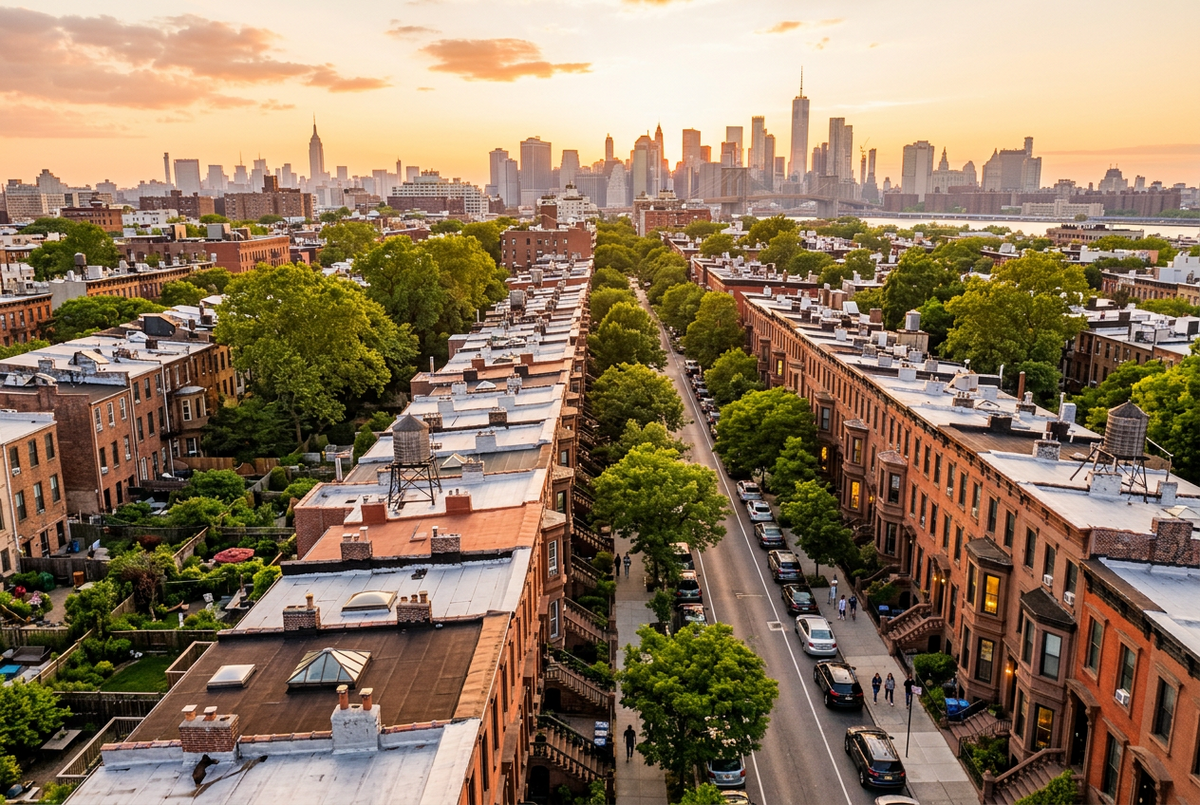
Only if your townhouse has something a street level camera cannot show, such as a deep garden, a roof deck, a skyline view or an unusual lot, and only if your timeline allows for New York City's drone permit process. For a standard interior rowhouse with a small yard, aerial photos usually add very little.
Key takeaways
- Any drone takeoff or landing in New York City requires a permit from the NYPD. This applies in Brooklyn, and it applies to your own property too.
- The NYPD asks for applications at least 30 days before the first flight. A 14 day review exists only for operators who already appear on a permit issued in the past 180 days.
- If you decide today, October 12, 2026, the earliest flight under the standard review is November 11, 2026.
- Photos are the listing feature buyers rate most useful. Floor plans outrank video by a wide margin. No public data we could find isolates the effect of aerial images on a Brooklyn townhouse sale.
- Use the six question Townhouse Aerial Value Test below to decide in about five minutes.
Why the law comes before the photography
Most articles about aerial photos for real estate treat the drone as a simple add on. In New York City it is not. Before July 2023, the city's Administrative Code prohibited most drone takeoffs and landings outright. Since July 21, 2023, the NYPD, working with the Department of Transportation, accepts applications for a takeoff and landing permit under 38 RCNY Chapter 24. The NYPD's own page states that a permit is required to take off or land any FAA registered, FAA compliant drone lawfully within the city.
Here is what the NYPD's published FAQ and permit page say an applicant must handle:
- A licensed pilot. Every application must name an operator who holds an FAA Part 107 Remote Pilot Certificate.
- Registration and FAA paperwork. The aircraft must be FAA registered, and FAA authorization documents and any waivers go with the application.
- Insurance. The City of New York must be listed as an Additional Insured on the operator's policy.
- A fee. The application fee is $150 and is not refundable.
- Community notice. If the drone will capture still images or video, the applicant must notify each affected community board and post notices within 100 feet of every takeoff and landing site. Expect a flyer near your block.
- Backup dates. Every date, including weather backups, must be in the original application. The NYPD does not allow date changes after submission.
- Private access. A permit does not reserve a location or grant entry. Operators must receive approval to enter or remain in private locations.
On top of the city rules, much of Brooklyn sits inside the Class B airspace around JFK and LaGuardia airports, where FAA authorization is required before a drone can fly. Operators who skip these steps may face criminal and civil penalties, and the NYPD has stated that a drone may be seized.
What the permit timeline means for your listing date
We took the NYPD's stated lead times and applied them to today's date. This is a calculation from the published rules, not a guarantee of approval.
| Review path | Lead time stated by the NYPD | Earliest first flight if applied for on October 12, 2026 |
|---|---|---|
| Standard review | At least 30 days | November 11, 2026 |
| Expedited review, for operators listed on a permit in the past 180 days with none revoked | 14 days | October 26, 2026 |
The practical conclusion is simple. If your townhouse goes live in under 14 days, a drone flight under the city's process is effectively off the table. If it goes live in 14 to 29 days, it is possible only with an operator who qualifies for the expedited review. Thirty days or more gives you room for rain dates.
What aerial photos can and cannot show for a townhouse
A drone image of a standard Brooklyn rowhouse often shows a flat roof and the tops of neighboring buildings. That is not what a buyer needs. Aerial images earn their place on a townhouse when they reveal one of five things:
- Garden depth. A deep yard looks short from the parlor floor. From above, buyers can judge its true length and shape.
- A roof deck and what surrounds it. Deck size, access and the view are hard to explain in words.
- Block and neighborhood context. Proximity to a park, the waterfront or a tree lined street is a selling point that ground photos miss.
- An unusual footprint. Rear extensions, additions or a carriage house are easier to read from above.
- Corner or wide lots. Extra frontage and side light show up clearly.
Aerials do not show interiors, the quality of the facade detail or the stoop. Those are better captured from the street and from inside. Aerials also cannot show how floors connect, which is where a floor plan does the work.
The Townhouse Aerial Value Test
We built this test around the permit timeline and the five things aerials can genuinely add. It is a decision tool, not a statistical model. Score each row from 0 to 2 and add the results.
| Factor | 0 points | 1 point | 2 points |
|---|---|---|---|
| 1. Outdoor space the street cannot show | None, or a paved patio | A small garden or terrace | A deep garden, large yard or roof deck |
| 2. Lot shape | Standard interior rowhouse | Wider than most, or semi detached | Corner, detached or double lot |
| 3. Context worth showing | Nothing notable | Tree lined block or nearby landmark | Park, waterfront or skyline view |
| 4. Footprint hard to read from the ground | Plain rectangle | Rear extension or addition | Carriage house, several structures or a complex layout |
| 5. Roof features | Plain roof | Skylights or a modest deck | Large deck, pergola, solar or planted roof |
| 6. Time before your listing goes live | Under 14 days | 14 to 29 days | 30 days or more |
How to read your score:
- 0 to 4: Skip the drone. Spend the budget on street level exterior images, garden photos and a floor plan.
- 5 to 8: Consider one or two aerial frames, or use the alternatives below.
- 9 to 12: Aerial images are likely worth the effort, and you have the time to do it legally.
Three worked examples
These are illustrative scenarios, not client cases.
| Scenario | Scores for factors 1 to 6 | Total | Verdict |
|---|---|---|---|
| Interior rowhouse, small paved yard, listing in 10 days | 1, 0, 0, 0, 0, 0 | 1 | Skip aerials. Invest in ground level photos and a floor plan. |
| Wide brownstone, landscaped garden, roof deck with a skyline view, listing in six weeks | 2, 1, 2, 0, 2, 2 | 9 | Aerials likely worth it. Start the permit process now. |
| Corner townhouse, mid size garden, across from a park, listing in three weeks | 1, 2, 2, 0, 1, 1 | 7 | Consider a small aerial set, or use roof deck photos and a floor plan. |
Alternatives that avoid the drone permit
If your score is low, or your timeline is tight, these options show much of what a buyer wants without the permit process.
| Option | What it shows | NYC drone permit needed | Scheduling |
|---|---|---|---|
| Drone flight with an NYPD permit | Garden depth, roof, block context | Yes | Plan for 14 to 30 days or more for permit review |
| Camera on a tripod from your roof deck or an upper window | The garden from above, skyline views | No, because no aircraft is flown | Scheduled like a normal shoot |
| Street level exterior and twilight photos | Facade, stoop, curb appeal | No | Scheduled like a normal shoot |
| Floor plan | How the floors connect and the room sizes | No | Scheduled like a normal shoot |
| 3D scan | A walkthrough of every level | No | Scheduled like a normal shoot |
Townhouses are vertical homes, and buyers often struggle to picture the flow across four or five levels. That is why a floor plan or a 3D scan often does more for a townhouse than an aerial image does.
What the buyer data does and does not say
According to figures from the National Association of Realtors 2025 Generational Trends report, as reported by Webtonic, buyers who used the internet rated these listing features as very useful:
| Listing feature | Buyers rating it very useful |
|---|---|
| Photos | 83% |
| Detailed property information | 79% |
| Floor plans | 57% |
| Virtual tours | 41% |
| Videos | 29% |
Two lessons follow. First, strong photography is still the most valued feature, so the quality of your core images matters more than any extra. Second, floor plans are valued by more than half of buyers, nearly twice the share for video.
What this data does not say is just as important. We could not find a public dataset that isolates the effect of aerial images on price or days on market for Brooklyn townhouses. Many vendors publish percentages that cannot be traced to a source. We do not repeat them here, and you should be cautious about any photographer who does.
Six questions to ask before you book aerial photos
- Do you hold an FAA Part 107 Remote Pilot Certificate?
- Will you apply for the NYPD takeoff and landing permit, and can I see it before the flight?
- Does your insurance name the City of New York as an Additional Insured?
- Where will the drone take off and land, and does that location need my approval or my building's?
- What is the plan for weather, given that permit dates cannot be changed after submission?
- How many aerial frames will I receive, and which ones will actually help my listing?
The NYPD also notes that operators must keep certain documents ready for inspection by law enforcement: the permit, a copy of the insurance policy, FAA authorization documents and a government issued photo ID. A professional should have no trouble showing you these.
Frequently asked questions
Do I need a permit to fly a drone at my own Brooklyn townhouse?
Yes. The NYPD requires a permit to take off or land an FAA registered, FAA compliant drone anywhere in the city, other than designated model aircraft fields. Owning the property does not change that.
How long does the NYPD drone permit take?
The NYPD asks for completed applications at least 30 days before the first proposed flight. A 14 day review applies only when every proposed operator was listed on a permit issued in the past 180 days and none of those permits were revoked.
How much does a drone permit cost in New York City?
The NYPD application fee is $150 and is not refundable. Insurance, the pilot's fee and the photography itself are separate costs.
Are aerial photos worth it for a Brooklyn townhouse?
They can be, when the property has a deep garden, roof deck, notable view or unusual lot, and when there is enough time for the permit. For a standard interior rowhouse with a small yard, they usually add little. Use the scoring test above.
Is Brooklyn airspace restricted?
Much of Brooklyn sits within the Class B airspace around JFK and LaGuardia airports, where FAA authorization is required before a drone can fly. The city's permit rules apply on top of that.
Do aerial photos help a townhouse sell faster or for more?
We could not find a public dataset that proves it for Brooklyn townhouses, so we do not claim it. What the National Association of Realtors data does show is that photos in general are the listing feature buyers value most.
What can I use instead of a drone?
Photos from your roof deck or an upper window, street level and twilight exterior images, a floor plan and a 3D scan. Together these cover most of what buyers look for without the permit timeline.
The bottom line
Aerial photos are a tool, not a requirement. For a Brooklyn townhouse with a deep garden, a roof deck or a view, and a listing date at least a month away, they can be worth doing properly and legally. For everything else, a strong set of ground level photos plus a floor plan will usually serve a buyer better, and will not put your timeline at risk.
Not sure where your townhouse lands? Our property photography service covers Brooklyn listings, and you can tell us about your property for a recommendation on what your listing really needs.

Leave a comment
This site is protected by hCaptcha and the hCaptcha Privacy Policy and Terms of Service apply.